
Space monitor for Hong Kong settlement
Sep 2011
Peter Kenyon, TunnelTalk
-

Satellite imaging is to be used to monitor ground movement on a major new Hong Kong project
- Revolutionary satellite imaging technology, which is so powerful it can detect ground movements measuring just millimetres a year, is being used to monitor the surface effects of underground construction work on the $5.4 billion Hong Kong Island Wan Chai highway bypass project.

-

Fig 1. Astrium's twin satellites
- Astrium, a European space company, has signed a contract with Hong Kong's Spatial Technology Limited to provide precise surface movement monitoring information for the construction of a 3.5km tunnel on Hong Kong Island, work on which started at a ground-breaking ceremony in January this year.
- The GEO-Information Services division of Astrium Services will utilise data from the Astrium-built TerraSAR-X and TanDEM-X radar satellites to provide surface movement information both before and during the tunnelling process (Fig 1).

- The TanDEM-X was launched from Kazakhstan in June 2010. This data that it, and its twin satellite, will collect is essential in order to ensure that the risks of tunnelling are reduced in what is a highly populated area with enormous real estate value, enabling project teams to understand the impact of the underground construction work on the site's surface, surrounding buildings and infrastructure.
-

Fig 2. Satellite image of Budapest
- The technology allows ground levels over large surface areas to be compared between each 11-day earth orbit of the satellites. This is possible regardless of cloud cover or weather-related interference.
- The technology was proven as a valid tunnelling information tool during a pilot programme on the recent excavation of running tunnels for the Budapest Metro in Hungary.
- Unlike existing terrestrial ground-monitoring methods, imaging from space using satellite technology allows large areas surrounding tunnel excavations to be swept for data enabling project managers to both identify and react to changes in subsidence or uplift not only along the tunnel route, but also in the surrounding area.

-
Budapest results
The technology recorded interesting and highly visible results during the construction phase of the Budapest subway (Fig 2), as well as in recording significant surface ground movement at oil drilling sites (Fig 3).
-

Budapest's Metro Line 4 passes under the ancient city centre and the River Danube
- In Budapest, satellite ground-movement imaging was used over fears that tunnelling works might threaten the medieval architecture of one of Europe's most historic cities.
- In the Hungarian capital a complex building project was initiated in 2006, when the founding stone was laid for the construction of a new Metro line which is planned to connect south-west Budapest with the north-western parts of the city, and comprises 16 stations along a length of 12.7km, to be completed by 2013.
- The tunnels of the new Metro Line 4 were excavated using TBMs, while the stations were constructed by a top-down method. During the construction, an extensive terrestrial surveying programme was established to monitor surface movements related to the construction.
- Results derived from TerraSAR-X data were compared to the terrestrial surveying.

-

Fig 3. Oilfield monitored movement
- Surface subsidence is made visible in the red-colour scale, while surface uplifts are colour-coded in the blue-colour scale. Multiple point ground-level scanning allows simultaneous pinpoint measurements to be taken across a wide area.
- From the map in Fig 2 it can be seen clearly that surface movements have occurred along a line from north-east to south-west of the River Danube. This corresponds exactly to the track of Metro Line 4 construction. Significant surface displacements of up to approximately 10mm/year were detected especially in the vicinities of the underground stations.
- Results from the drilling site at the Burghan oilfield in Kuwait also showed ground subsidence in key production sites as a result of underground activity (Fig 3).
-
Contract signed for Hong Kong
On July 25, following the successful pilot of the technology in relation to tunnelling work in Budapest, Astrium signed a contract to provide similar information during the construction phase in Hong Kong.

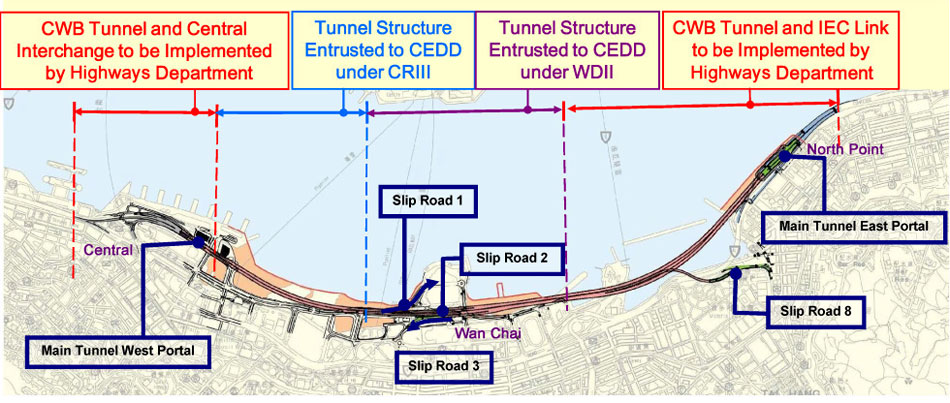
- The tunnel under construction (in several sections) forms part of the Wan Chai Bypass Project, a 4.5km section of highway running along the northern part of Hong Kong Island that, when opened in 2017, will improve transport links in the region and reduce traffic congestion.
-

Hong Kong highway bypass tunnel route
- Ralf Duering of the GEO-Information Services division of Astrium Services in China said: "The Wan Chai Bypass Project represents a significant technical challenge. Precision engineering is crucial when tunnelling in areas that are highly populated, so the information provided by Astrium will play a key role in the effective management of the construction process."
- "We are delighted to work with Astrium in integrating their surface motion data into our Site Data Management System (SDMS) to be deployed in this project, enabling our customer to enjoy reliable and accurate data monitoring with maximum area coverage and time/cost efficiency", said Andy Cheung, the General Manager of Spatial Technology Ltd.
-
Budapest metro standoff resolved - TunnelTalk, May 2009
ITA post congress analysis - TunnelTalk, June 2009
|
|
|
|
|
Add your comment
- Thank you for taking the time to share your thoughts and comments. You share in the wider tunnelling community, so please keep your comments smart and civil. Don't attack other readers personally, and keep your language professional.