Kerch Tunnel to guarantee security for Crimea 18 May 2015
Déjà vu! Almost immediately after President Vladimir Putin of Russia remarked on the necessity to build a transport crossing of the Kerch Strait to the Crimea Peninsula, the classic ‘lyrical poets against physicists’ dilemma re-emerged. What is the real need of Crimea? Is it a bridge or a tunnel? And here again the proverb ‘every bird likes its own nest’ comes to mind. While bridge engineers are defending a bridge strait crossing as a beautiful, aesthetically pleasing, effective, picturesque and inexpensive solution (from their viewpoint), the tunnel engineers argue in the opposite direction, promoting the tunnel option as the safest, most reliable and the most durable of engineering structures.
The bridge option, undoubtedly, has a lot of advantages, while at the same time being the most vulnerable of structures to both natural hazards, such as thunderstorms, typhoons, earthquakes, and ice drifts, and to terrorist attacks or local military conflicts. The above factors encourage further comparison between bridge and tunnel solutions proposed for the Kerch Strait crossing.
First attempt
The idea of a transport crossing of the Kerch Strait dates back a long time. And it was not only an idea. The Second World War made the idea of a fixed link especially significant, and the construction works started. A detailed description of these can be found in the M S Rudenko article Bridge over the Kerch Strait published in the Transportnoye Stroitelstvo (Transport Construction) magazine No 6, 1991.
The bridge, of 4,452m in total length, was built north of Kerch. It had more than 100 spans of 13.6m and 27.3m in length, and four swing spans of 2 × 55m and 2 × 27m in dimension in its channel section for allowing vessels to pass. The construction was completed for the most part in Autumn 1944, and on November 3, the first train passed over the bridge from the Krim Station on the Crimean side to the Kavkaz Station on the Caucasus side.
In February 1945, after the Yalta conference, a closely guarded train passed over the bridge in the same direction. But a few days later, on 18-20 February, part of the bridge was destroyed by a sea ice drift. The ice floes, moved by wind and current, approached the bridge from the Azov Sea, and 15 intermediate spans were destroyed under the force.
Following this accident, the Government of Russia decided not to make any attempt to launch either a high level fixed bridge or a movable bridge project for many years. Talks about the necessity of this crossing, for both rail and road transport, were resumed only after the USSR collapsed and Russia and Ukraine became separate states. Various projects were proposed, including bridges and tunnels, but all of them failed to achieve intergovernmental approval.
Location
The Kerch Strait runs between the Black Sea and the Sea of Azov, enabling a transport link between them (Fig 1). It is bounded by the Taman Peninsula to the east, and by the Kerch Peninsula to the west. The length of the Strait is about 25km, while its width ranges from 4.5km in its northern part near Chushka Spit, up to 16km in its southern part near the Tuzla Spit. Water depths range from 5–8m to the north and 3–6m in the south.
Marine traffic between the Black Sea and the Azov Sea is via the Kerch-Yenikalsky navigable dredged channel of about 8-10m deep and 120m wide along the Kerch Strait, about 2.5km from the Crimean coast. Both heavy-tonnage vessels of between 150m-240m long and up to 50m high, as well as oil and gas platforms up to 94m in height, pass through the Strait. More than 21,000 vessels, including more than 500 heavy-tonnage vessels, pass through the Strait each year.
The Taman Peninsula features a hilly topography, slightly sloping to the sea and ridged in its central part and with the coastline indented with bays and estuaries.
The Kerch Peninsula is also of hilly terrain, formed by narrow hills and ridges split by gentle depressions of various sizes. Hillsides and ridges slope at 10-35 degrees. The Kerch Strait shoreline is diverse, with low and swampy areas and sand spits near Chushka and Tuzla giving way to steep rocky cliffs. The water exchange through the strait is conditioned mainly by winds and by the flow of water from the Azov Sea. The water level depends on many factors, and above all on sea level variations caused by the wind. Mean annual cycle of sea level height is estimated from 35cm to 97cm, and the maximum current velocity is 0.98m/sec. The ice in the strait forms annually. It is moved mainly by north-east winds from the Azov Sea.
Storm warning
Forceful storms occur in the Strait, especially in winter. The last storm of October 11, 2007, caused several ships to sink, resulting in the release of oil and sulphur into the water, contaminating the Crimean Peninsula coast.
Average annual wind velocity observed by meteorological monitoring stations across the Kerch Strait ranges from 4–8m/sec with north-east and east winds being the strongest with the absolute maximum of more than 40m/sec recorded by a north wind in September 1956. Wind gusts can reach peak speeds of 228m/sec.
According to available data, the Kerch Strait is located in a highly seismic area with seismicity anticipated at 9 on the Richter scale and with a 1% probability of exceeding this. A structural feature of the area is the high location of the argillaceous bedrock near the Crimea and its dramatic drop off to a depth of 50m in the eastern part of the Strait. Very weak sedimentary deposits cover the bedrock.
Crossing options
The recent return of Crimea to the Russian Federation has brought with it fresh impetus for construction of a new Kerch crossing. Early bridge crossing proposals were submitted for discussion, though these did not reflect the new realities of worsening international relations and the growing menace of terrorism.
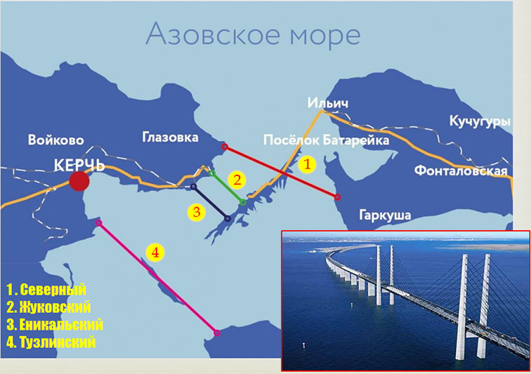
The location of a bridge crossing has been analysed intensely during the past few years, with four main frontrunners identified Fig 2:
- 1. The Northern crossing in the Cape Fonar area, at the mouth of the Strait on the Azov Sea side;
- 2. The Zhukovsky crossing that follows the route of the existing ferry boat crossing;
- 3. The Yenikalsky crossing to the south of the ferry crossing, between the Yenikale Cape and the southernmost tip of the sand spit Chushka;
- 4. The Tuzla crossing in the old fortress area in the zone south of the Cape Ak-Burun White to the Tuzla sand spit.
The technical and economic parameters of the four frountrunners, as prepared by the institute Giprostroymost have been thoroughly studied
(Table 1).
According to bridge experts, who refer to technical and economic comparative studies, in every possible location the minimum navigable span length should be no less than 320m and up to 500m in the Kerch-Yenikalsky navigable sea channel. Large ice floes from the Azov Sea, and eventual sea ice blocking of the strait, constitute a serious disadvantage for the Northern solution.
| Table 1. Estimated technical and economic parameters of the main bridge crossing options | |||||
| Indicators | Units | Sites | |||
| Northern | Zhukovsky | Yenikalsky | Tuzla | ||
| Length of bridge crossing | m | 10,250 | 5,670 | 6,300 | 11,700 |
| Approaches* Rail link Road link |
km km |
24/86 49/40 |
13/94 46/79 |
5/93 46/89 |
36/83 38/45 |
| Superstructure steel works | tonne | 160,000 | 114,000 | 127,000 | 183,000 |
| Concrete requirements | m3 | 695,000 | 496,000 | 550,000 | 790,000 |
| Construction cost: Bridge crossing Approach to bridge crossing Infrastructure facilities |
US$ million | 943.6 422.0 150.0 |
693.1 579.0 150.0 |
746.1 570.0 150.0 |
1077.08 407.0 150.0 |
| Occupied area | Hectares | 108,000 | 116,000 | 112,000 | 102,000 |
| Construction period | Years | 6 | 6 | 6 | 6 |
The Zhykovsky and Yenikalsky options face the same problem, though to a lesser degree. In addition, Zhykovsky option passes a sharp turn in the Kerch-Yenikalsky sea channel that is unacceptable as it contravenes navigation regulations.
The Tuzla option has a characteristic feature in that the bridge would pass over a sharp turn of Kerch-Yenikalsky sea channel, close to the reloading bay of the port at Kerch. There is also the advantage of the high coastline at this location being almost the same level as the bridge, which would eliminate the need for lengthy low-gradient approaches on either side of the bridge for roadways and railways. As a result, the crossing length could be decreased, although the navigable span would probably need to increase.
A preliminary comparison of bridge location options in terms of environmental conditions and navigation safety, illustrates clear advantages for the Tuzla scheme. It is located at the narrowest navigational span of the strait, where navigation is restricted by the steep coast on the Crimea side, and by shallow waters and the Tuzla spit on the Caucasus side. This option is recommended as a priority for further scrutiny.
Three tunnel options
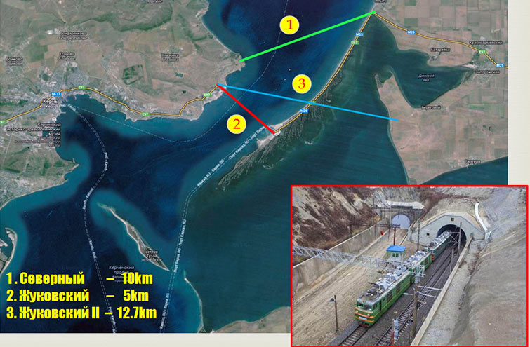
Options for a proposed tunnel crossing are similar to those for the bridge schemes, with three viable alternatives presented (Fig 3).
The Northern option envisions a tunnel link between Cape Fonar with the Ilyitch village. The direct route would be about 10km long. Taking into account the tunnel depth, and in conjunction with rail and road gradient requirements, the length of the crossing would reach 12km at this location.
The Zhukovsky option, like its bridge alternative, underlies the existing ferry crossing, and would link Zhukovka on the Crimean coast with Chushka sand spit on the Taman Peninsula. The direct route would be about 5km long, and, taking tunnel depth and gradients into account, would extend to about 7km.
The third option, Zhukovsky II, calls for a tunnel between Cape Fonar and the town of Garkusha. A direct route would be about 12.7km, increasing to 15km long when taking into account the necessary gradient considerations.
All tunnel proposals are competitive in terms of time and cost with their bridge alternatives.
Advantages of the tunnel solution
The bridge that was built 70 years ago ended up being destroyed by a natural disaster, proof of the vulnerability of a bridge crossing. However, there are other sound arguments in favour of the tunnel alternative, the most important being the cost-time factor, navigation safety, environmental impact considerations, constructability and longevity (Table 2). The largest concern is cost. It is a considered norm that bridges are less expensive than tunnels. However, in this particular case, a combined railway and highway bridge with spans of more than 60m high and abutment piles of up to 55m deep, the tunnel would cost, if not less, then at least not much more. This means that the costs are in fact comparable.
This being the case, it is safety criteria that are likely to be a key consideration when it comes to selecting the type of structure for the Kerch Strait crossing. The structure itself, once built, will also become a strategic security issue for Crimea.
Tunnel cost studies
Tentative cost estimates for a double-deck road-rail tunnel range from €1.8 billion for a 7km tunnel, to €2.9 billion for the 12km tunnel option. This is comparable to the cost of a bridge of similar length.
| Table 2. Main comparison criteria for bridge and tunnel | ||||
| No | Criteria | Bridge | Tunnel | Note |
| 1 | Cost | + | - | Ambiguous, depends upon local conditions |
| 2 | Construction time | - | + | Ambiguous, depends upon local conditions |
| 3 | Strategic security | - | + | Invariable |
| 4 | Navigation safety | - | + | Invariable |
| 5 | Weather conditions | - | + | Invariable |
| 6 | Environmental impact | - | + | Invariable |
| 7 | Constructability | - | + | Rather yes |
| 8 | Operating availability | - | + | Rather yes |
For example, the cost of the bridge across the Eastern Bosporus Strait to Russky Island, at a total length of 1,885m, amounted to approximately €1 billion with construction taking four years (2008-2012). Considering that this bridge is road-only, a combined road-rail bridge of the type specified for the Kerch crossing could theoretically turn out even more expensive than the tunnel option. However, this assertion requires careful scrutiny.
Another example is the 3.2km road bridge across the Lena River in the Yakoutsk region, which is currently in design and planned to be built within the framework of a concession agreement. It has a cost estimate of RUB40.25 billion (2013 prices, US$800 million at 2015 exchange rate). By way of comparison, the cost estimate of the current 5.4km double-deck tunnel across the Bosphorus Strait in Instanbul, Turkey, featuring two vehicle lanes in each direction, is about US$1.4 billion or about RUB56 billion (2013 prices) (Fig 4). Based on the above, the cost of the Kerch Strait tunnel crossing is comparable to that of a Kerch Strait bridge crossing.
Construction time and constructability
All other conditions being equal, the tunnel construction time might turn out shorter for the proposed tunnel than for a bridge. A 7km long tunnel of 19.3m in diameter and excavated using a mega-TBM of more than 19m diameter, could be built in 4.5 to 5 years based on using one tunnelling machine and achieving a progress rate of up to 4.4m or two rings per day. A similar bridge construction, all other conditions being equal, would take an estimated 6-7 years.
Prevailing geological conditions, especially in the waterway area, would complicate bridge construction, and require 80m high piers supported on 50m deep-bored piles. According to available data, the construction period of the Lena River bridge is expected to last for at least 5 years.
Tunnels are undeniably more constructible than bridges. Having once determined the tunnel diameter, tunnel lining thickness and other parameters, the constructor can go ahead and realize the project using a limited number of standardized components. In the case of a bridge crossing, the stock of products required might appear to be much wider, and the construction methods more varied, impacting inevitably upon progress and structural safety.
Navigation, weather, strategic security
Navigation and marine safety become fundamental design, construction and operational issues in the case of a bridge crossing, but have no bearing on a tunnel solution.
Weather conditions would also have limited bearing on the time and cost of tunnel construction. On the contrary, bridge construction is especially vulnerable to climate conditions such as winds, storms, ice drifts and landslides, all of which could combine to significantly increase time and costs, particularly during construction work in the waterway itself.
Of all engineered structures, tunnels are among the safest, being well protected against various threats including those of natural disaster and potential terrorist attack. Subsea tunnels have no access other than at the portals, they cannot be seen from a distance, and they are protected by rock mass and water. As with any subterranean structure, when built accordingly a tunnel is also more resistant to local seismic hazards. Special water suppression systems also make tunnels less vulnerable to fire while the potential of explosion-resistant sprayed concrete lining presents the possibility of further protection for underground infrastructure.
Environmental impact, reliability
A bored tunnel has the advantage also of limited environmental impact compared to a bridge option. It also has an advantage in terms of life-cycle longevity. According to national and international standards the structural longevity of bridges or tunnels should be no less than 100 years, with European norms requiring no less than 120 years). Accordingly, we must admit the obvious fact that bridges are less durable than tunnels. The conclusion is that the comparison of two Kerch Strait crossing alternatives suggests that the bored tunnel option is preferable.
Design solutions for tunnel crossing
Our team at Plato Engineering has developed the following three design solutions for a tunnel crossing.
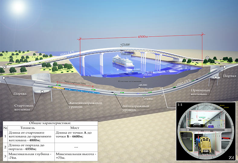
- 1. A single double-deck tunnel of 18.65m external diameter with three 3.65m wide vehicle lanes in the upper level and a twin-track railway in the lower level. The option complies with all regulatory dimension requirements for rail and road transport and allows passengers to pass from one level to another in case of an emergency evacuation (Fig 5).
- 2. A single double-deck tunnel of 16m external diameter with two 3.65m wide vehicle lanes and a motorway barrier between them on the upper level and a single railway track on the lower level. This option also allows passengers to pass from one level to another in case of an emergency evacuation (Fig 6).
- 3. A twin tube double-deck tunnel, each of 15.2m in external diameter with two 3.65m wide vehicle lanes and a motorway barrier between them in the upper level and one railway track in the lower level of each tube and with emergency cross-passages between the tunnels at 50m spacings (Fig 7). A similar option was successfully implemented for the Yangtze River crossing in Shanghai, China.
The following tunnels, which are either already built or are at various stages of design, could be listed as examples of similar tunnel solutions:
- The undersea tunnel Seikan in Japan, 53.85km in length, completed in 1988 and running at 240m below the sea level.
- The undersea 50.5km Channel Tunnel or Eurotunnel, which opened to passenger services in 1994.
- The Afro-European tunnel under the Strait of Gibraltar, proposed as a 38.7km crossing.
- The Asian-European 5.4km double-deck motorway tunnel under the Bosporus Strait and currently in construction.
- The Orlovsky double-deck motorway city tunnel of about 6km in overall length under the Neva River in Saint Petersburg, Russia, approved by the State Examination in 2010 and awaiting financial approval.
These examples bring us to two important conclusions:
- Almost all western countries, when faced with the necessity of crossing wide waterways normally make decisions in favour of tunnels. In some cases bridge options are not given serious consideration at all.
- The last decades are marked by a remarkable positive experience in successful design and construction of undersea tunnels for both motorway and railway in various geological and geotechnical conditions. Advanced technical concepts and tunnelling equipment are available on the market and today, many well-trained engineers, technicians and workers are capable of implementing state-of-the-art tunnel projects.
Under the above arguments, we are forced to admit that the advantages of the tunnel option are undeniable. Having said that, we must certainly acknowledge that, without a doubt, the transport crossing of the Kerch Strait is a challenging and difficult engineering task in view of the location, climatic, engineering, geological, seismic and other conditions of the area.
References
- Mega dimensions of Russian Orlovski Project Video – TunnelTalk, September 2012
- Russia confirms order for largest TBM ever – TunnelTalk, August 2011
- St Petersburg tunnel moving forward – TunnelTalk, January 2010
- Two new mega drives under the Yangtze – TunnelTalk, September 2009
- TBM to take on Bosphorus highway crossing – TunnelTalk, August 2013
- Channel Tunnel handshake of history – TunnelTalk, December 2010
- Tracking the world's mega-TBMs – TunnelTalk Discussion Forum
- From the TunnelTalk Archive
- Foundation of a new Ashgabat – TunnelTalk February 2006
- Ambitious project planning in Kiev – TunnelTalk July 2007
- Speedy mega TBM for Moscow Lefortovo highway – TunnelTalk October 2002
|
|
|
|
|
Add your comment
- Thank you for taking the time to share your thoughts and comments. You share in the wider tunnelling community, so please keep your comments smart and civil. Don't attack other readers personally, and keep your language professional.


